
Tour du Saint-Bernard
Beschreibung
- Name Tour du Saint-Bernard (TSB)
- Länge in Tagen 6 Tage
- Anfang von Wanderweg Bourg-Saint-Pierre
- Ende von Wanderweg Bourg-Saint-Pierre
- Traildino Schwierigkeit SW, Anspruchsvolle Wanderung, Bergwanderung
- Schwierigkeitsgrad Berg- und Alpinwanderung T2, Bergwandern
6 days. Circular tour from Bourg-Saint-Pierre.
Select some tracks
☐Tour du Saint-Bernard, 86km
Karte

Links
Fakten
Berichte
Führer und Karten
Übernachtung
Organisationen
Reisebüros
GPS
Sonstiges
Karten
De Zwerver
Netherlands
2011
Netherlands
2011
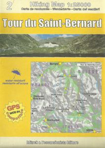
- Wandelkaart TRK02 Tour du Saint-Bernard | L'Escursionista editore
- Tour of Saint-Bernard long-distance hiking route presented on a waterproof and tear-resistant, contoured and GPS compatible map at 1:25,000 published jointly by L Read more
- Also available from:
- Stanfords, United Kingdom

Stanfords
United Kingdom
2011
United Kingdom
2011
- Tour of Saint-Bernard L`Escursionista Editore Map-Guide
- Tour of Saint-Bernard long-distance hiking route presented on a waterproof and tear-resistant, contoured and GPS compatible map at 1:25,000 published jointly by L’Escursionista Editore and Editrek, plus a separate multilingual guide booklet with stage by stage descriptions and other tourist information.Contour interval is 25m and the map has... Read more