The Book Depository
United Kingdom
» Click to open
Stanfords
United Kingdom
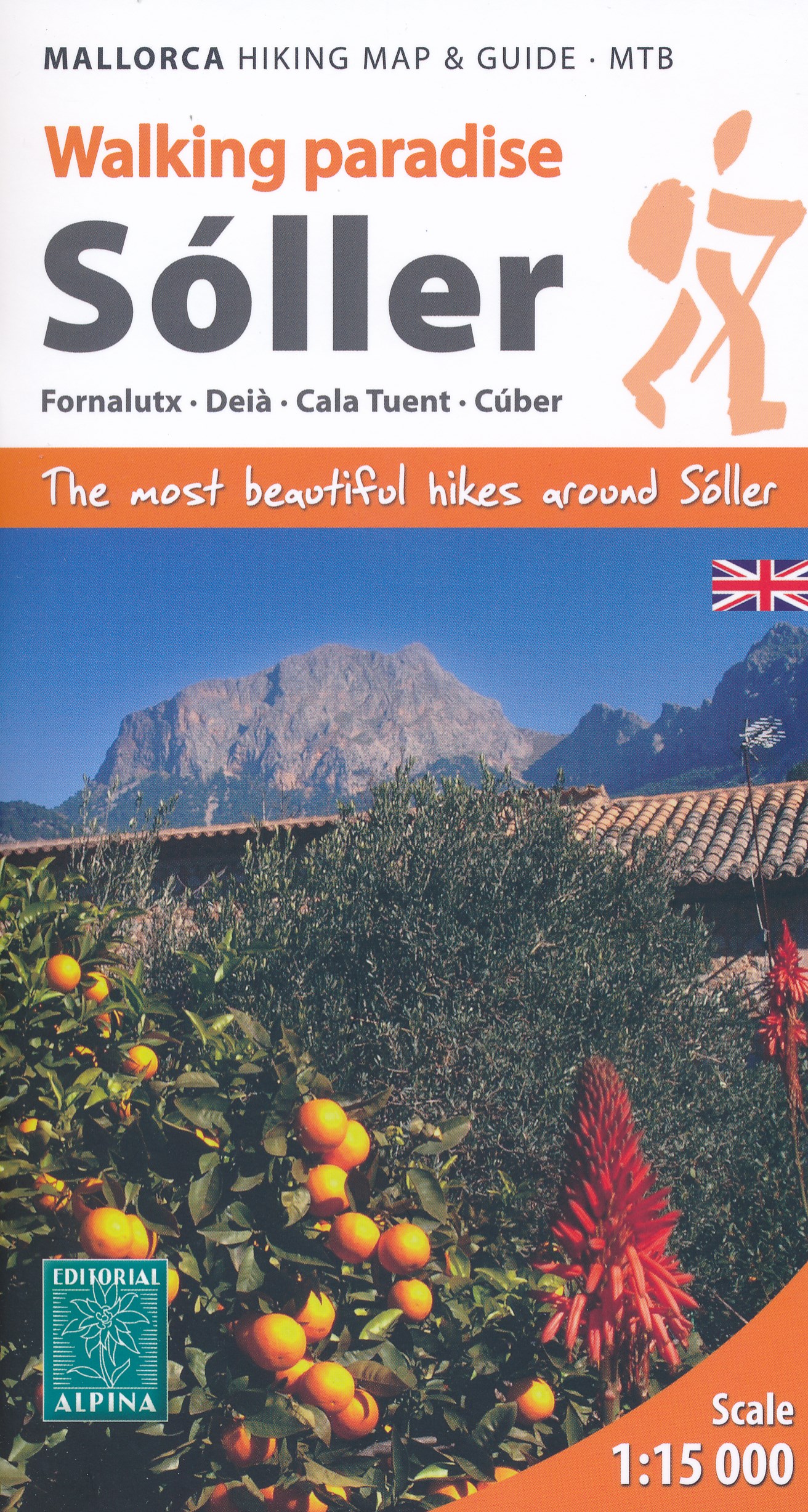
  • Sóller - Mallorca Editorial Alpina Map & Guide ENGLISH
  • The Valley of Sóller in Mallorca’s Serra de Tranumtana on a very detailed, GPS compatible recreational map at 1:15,000 from Editorial Alpina with hiking routes, mountain bike trails, etc, plus an English language guide with 54 walks. The map has Sóller itself towards its southern edge, and extends in the coastal area from Deià in the south... Read more
» Click to close
The Book Depository
United Kingdom
» Click to open
De Zwerver
Netherlands
  • Wandelkaart 68 Tramuntana Noord GR221 Mallorca | Editorial Alpina
  • Zeer gedetailleerde wandelkaart van een deel van de Tramuntana op Mallorca. Met ingetekende wandelroutes en andere informatie. uitstekende kaart. Met symbolen voor campings, hutten. Let op: deze uitgever is traag met het vernieuwen van kaarten; het kan zo maar zijn dat een bepaalde kaart gedurende langere tijd niet beschikbaar is. Majorca:... Read more
Stanfords
United Kingdom
  • Mallorca - Tramuntana North Editorial Alpina
  • The northern part of Mallorca’s Serra de Tramuntana mountains on a contoured and GPS-compatible map at 1:25,000 from Editorial Alpina, highlighting numerous local hiking trails and the course of the GR221 long-distance trail, climbing and canyoning sites, refuges and campsites, etc. Accompanying booklet includes English-language descriptions of... Read more
» Click to close
The Book Depository
United Kingdom
» Click to open
De Zwerver
Netherlands
  • Wandelkaart 67 Tramuntana Central - Mallorca | Editorial Alpina
  • Zeer gedetailleerde wandelkaart van een deel van de Tramuntana op Mallorca. Met ingetekende wandelroutes en andere informatie. uitstekende kaart. Met symbolen voor campings, hutten. Let op: deze uitgever is traag met het vernieuwen van kaarten; het kan zo maar zijn dat een bepaalde kaart gedurende langere tijd niet beschikbaar is. Majorca:... Read more
Stanfords
United Kingdom
  • Mallorca - Tramuntana Central Editorial Alpina
  • The central part of Mallorca’s Serra de Tramuntana mountains on a contoured and GPS-compatible map at 1:25,000 from Editorial Alpina, highlighting numerous local hiking trails and the course of the GR221 long-distance trail, climbing and canyoning sites, refuges and campsites, etc. Accompanying booklet includes English-language descriptions of... Read more
» Click to close
De Zwerver
Netherlands
De Zwerver
Netherlands
» Click to open
Stanfords
United Kingdom
  • Mallorca F&B
  • Majorca at 1:50,000 on a large, double-sided, contoured map from Freytag & Berndt, with highlighting for scenic roads and tourist routes, plus a booklet with a GPS-annotated index, street plan of central Palma, and multilingual descriptions of the island’s best sights.Topography is shown by contours at 100m intervals, with numerous spot height,... Read more
» Click to close
De Zwerver
Netherlands
De Zwerver
Netherlands
» Click to open
Stanfords
United Kingdom
  • Mallorca North Walking & Cycling Map & Guide Editorial Alpina
  • Mallorca North Walking & Cycling Map & Guide set from Editorial Alpina, with a double-sided, contoured and GPS compatible map at 1:25,000, plus a booklet with English language descriptions of 90 hiking routes from various locations.The map covers two areas on the north-eastern coast of Mallorca: one side Cap de Formentor with Cap des Pinar... Read more
» Click to close
De Zwerver
Netherlands
2022
» Click to open
Stanfords
United Kingdom
2022
  • Mallorca F&B Road and Leisure Map
  • Majorca at 1:50,000 on a large, double-sided, contoured map from Freytag & Berndt, with highlighting for scenic roads and tourist routes, plus a booklet with a GPS-annotated index, street plan of central Palma, and multilingual descriptions of the island’s best sights.Topography is shown by contours at 100m intervals, with numerous spot height,... Read more
» Click to close
De Zwerver
Netherlands
» Click to open
Stanfords
United Kingdom
  • Mallorca - Tramuntana South Editorial Alpina
  • The southern part of Mallorca’s Serra de Tramuntana mountains on a contoured and GPS-compatible map at 1:25,000 from Editorial Alpina, highlighting numerous local hiking trails and the course of the GR221 long-distance trail, climbing and canyoning sites, refuges and campsites, etc. Accompanying booklet includes English-language descriptions of... Read more
» Click to close
De Zwerver
Netherlands
» Click to open
Stanfords
United Kingdom
  • Balearic Islands Province 200K CNIG Map No. 8
  • Contoured, GPS-compatible, indexed road map at 1:200,000 from CNIG - Spain’s civilian survey organization, with exceptionally informative presentation of the landscape and highlighting for facilities and places of interest including campsites and paradors.Maps in CNIG’s 200K Provincial Series provide an excellent picture the topography through... Read more
» Click to close
De Zwerver
Netherlands
2014
» Click to open
Stanfords
United Kingdom
2014
  • Mallorca North Reise Know-How
  • Northern Mallorca at 1:40,000 in a series of four GPS compatible, double-sided maps from Reise Know-How printed on light, waterproof and tear-resistant synthetic paper, with very clear presentation of the road network, plus selected hiking and cycling routes.Maps in this series have contours at 100m intervals, enhanced by altitude colouring,... Read more
» Click to close
De Zwerver
Netherlands
2024
De Zwerver
Netherlands
» Click to open
Stanfords
United Kingdom
  • Ibiza - Formentera F&B
  • Ibiza and Formentera at 1:40,000 on a road map from Freytag & Berndt prominently highlighting the two islands’ best sights which have multilingual descriptions in the index booklet attached to the map cover. Road network is shown on a base with topography indicated by relief shading with spot heights, plus colouring for woodlands. Driving... Read more
» Click to close
De Zwerver
Netherlands
2012
» Click to open
Stanfords
United Kingdom
2012
  • Mallorca South Reise Know-How
  • Southern Mallorca at 1:40,000 in a series of four GPS compatible, double-sided maps from Reise Know-How printed on light, waterproof and tear-resistant synthetic paper, with very clear presentation of the road network, plus selected hiking and cycling routes.Maps in this series have contours at 100m intervals, enhanced by altitude colouring,... Read more
» Click to close
De Zwerver
Netherlands
» Click to open
Stanfords
United Kingdom
  • Mallorca Editorial Alpina Cycling Map
  • Mallorca at 1:100,000 on a double-sided cycling map from Editorial Alpina printed on light, waterproof and tear-resistant plastic paper. Roads are classified according to density of traffic and six route profiles are included.The map is double-sided, dividing the island east-west with a small overlap between the sides. Topography is shown by... Read more
» Click to close