The Book Depository
United Kingdom
2021
» Click to open
Stanfords
United Kingdom
2021
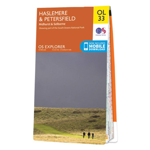
  • Haslemere & Petersfield - Midhurst & Selborne OS Explorer Map OL33 (paper)
  • Haslemere and Petersfield area of Hampshire, Sussex and Surrey on a detailed topographic and GPS compatible map OL33, paper version, from the Ordnance Survey’s 1:25,000 Explorer series. Coverage extends from Alton and Witley southwards to Midhurst, and includes parts of the South Downs National Park and the Surrey Downs Area of Outstanding... Read more
» Click to close
The Book Depository
United Kingdom
» Click to open
Stanfords
United Kingdom
» Click to close
The Book Depository
United Kingdom
2021
» Click to open
De Zwerver
Netherlands
2021
  • Wandelgids Park Rangers Favourite Walks South Downs | Collins
  • Walking guide to the South Downs National Park, with 20 best routes chosen by the park rangers. Each walk varies in length from 2 to 10 km and can be completed in less than 4 hours. 20 best routes chosen and written by National Park rangers Walks from 2 to 10kmDetailed description for each walk with highlights clearly marked... Read more
» Click to close
The Book Depository
United Kingdom
» Click to open
Stanfords
United Kingdom
  • Atkinsons Walks V1 - Southern England
  • ”ATCHISON`s Complete Hills of Britain Series” is a comprehensive guidebook series in 10 volumes. Each book divides a region of Britain into 50 separate walking areas, each with a major impressive hill to walk around - or ascend. It illustrates 3 superb walks for each area; a 2hr easy walk, a 3-4 hrs keep fit walk, and a challenging 5-7 hour... Read more
» Click to close
The Book Depository
United Kingdom
2022
» Click to open
Stanfords
United Kingdom
2022
» Click to close
The Book Depository
United Kingdom
The Book Depository
United Kingdom
2018
The Book Depository
United Kingdom
2020
» Click to open
De Zwerver
Netherlands
2020
Stanfords
United Kingdom
2020
  • South Downs Way - Easy-to-use Folding Map and Essential Information
  • The 162-kilometre South Downs Way begins in Winchester and traces a ridgeline along the rolling, green South Downs to the coast at Eastbourne. It is rightly regarded as one of the finest long-distance trails in England. Predominantly bridleway, the trail is generally wide and hard-surfaced and can be walked at any time of year. The South Downs... Read more
» Click to close
The Book Depository
United Kingdom
» Click to open
Stanfords
United Kingdom
  • Chichester, South Harting and Selsey OS Explorer Active Map OL8 (waterproof)
  • Chichester, South Harting and Selsey area of Sussex and Hampshire on a detailed topographic and GPS compatible map OL8, waterproof version, from the Ordnance Survey’s 1:25,000 Explorer series. Coverage along the coast extends from Pagham westwards across Selsey Bill and Hayling Island to Langstone Harbour, and includes part of the South Downs... Read more
» Click to close
The Book Depository
United Kingdom
» Click to open
Stanfords
United Kingdom
  • The South Downs A Dog Walker`s Guide
  • With its ancient woodland, river valleys and rolling hillsides, the South Downs, spanning the southern coastal counties of Hampshire and Sussex, is a dog-walker`s delight.This collection of 20 tried-and-tested circular walks has been written specifically for dogs and their owners, allowing for maximum off-lead time. These routes, covering the... Read more
» Click to close
The Book Depository
United Kingdom
» Click to open
Stanfords
United Kingdom
  • Chichester, South Downs, Bognor Regis & Arundel OS Landranger Map 197 (paper)
  • Chichester and Bognor Regis area, including the South Downs National Park and a section of the South Downs Way / E9 European Long-distance Path, on a paper version of map No. 197 from the Ordnance Survey’s Landranger series at 1:50,000, with contoured and GPS compatible topographic mapping plus tourist information.MOBILE DOWNLOADS: As well as... Read more
» Click to close
The Book Depository
United Kingdom
» Click to open
Stanfords
United Kingdom
» Click to close
The Book Depository
United Kingdom
» Click to open
Stanfords
United Kingdom
» Click to close
The Book Depository
United Kingdom
2019
» Click to open
Stanfords
United Kingdom
2019
  • Sussex: AA 50 Walks
  • Walking is one of Britain`s favourite leisure activities, and AA 50 Walks in Sussex features a variety of mapped walks of two to ten miles, to suit all abilities. The book features all the practical detail you need, accompanied by fascinating background reading on the history and wildlife of Sussex, and clear full colour mapping for ease of... Read more
» Click to close
The Book Depository
United Kingdom
» Click to open
Stanfords
United Kingdom
  • Winchester, Basingstoke, Andover & Romsey OS Landranger Map 185 (paper)
  • Winchester and Basingstoke area, including the westernmost part of the South Downs National Park and a section of the South Downs Way, on a paper version of map No. 185 from the Ordnance Survey’s Landranger series at 1:50,000, with contoured and GPS compatible topographic mapping plus tourist information.MOBILE DOWNLOADS: As well as the... Read more
» Click to close