
New Jersey
Beschreibung
New Jersey borders on the Atlantic. This state is very populated. Hiking is best in the mountainous northern part, with several state parks and forests. Here are 72 miles of the Appalachian Trail.
The Highlands Trail is supposed to connect New Jersey to New York, Pennsylvania and Connecticut, 150 miles.
Another important trail is the Long Path, 326 miles, also in the state of New York.
The Great Eastern Trail, East Coast Greenway and Eastern Continental Trail run through New Jersey.
Karte

Wanderwege Landesteil
Links
Fakten
Berichte
Führer und Karten
Übernachtung
Organisationen
Reisebüros
GPS
Sonstiges
Bücher

- Also available from:
- De Zwerver, Netherlands
- Stanfords, United Kingdom
De Zwerver
Netherlands
2019
Netherlands
2019
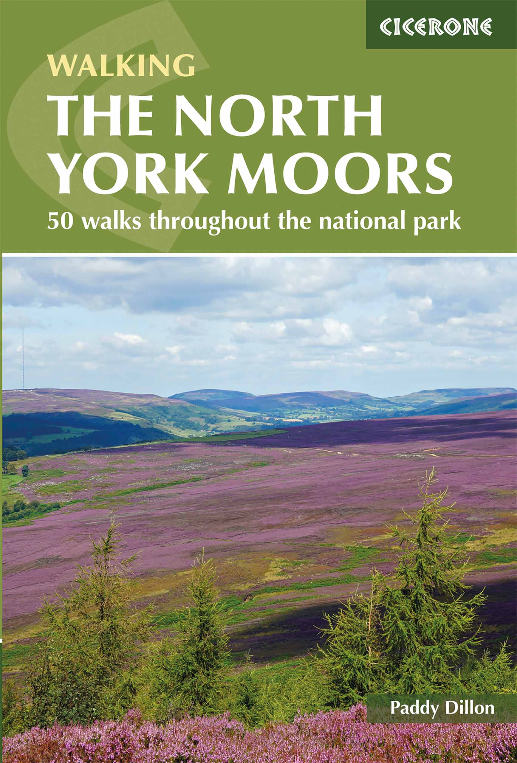
- Wandelgids The North York Moors | Cicerone
- Guidebook describing 50 varied walks in England's beautiful North York Moors National Park. Showcasing the region's sweeping moorlands, sheltered valleys, woodlands and cliff coasts, routes range from short and easy low-level walks to long and strenuous routes across the high moors, including the Lyke Wake Walk. Read more

Stanfords
United Kingdom
2019
United Kingdom
2019
- The North York Moors: 50 walks in the National Park
- Guidebook to 50 walks in the North York Moors National Park. The walks, which range from 4 to 13 miles, are distributed through seven regions within the park, enabling walkers to discover and appreciate the Tabular Hills, Hambleton Hills, Cleveland Hills, Northern Moors, High Moors, Eastern Moors and Cleveland Coast. For those who like a... Read more

- Also available from:
- Stanfords, United Kingdom

Stanfords
United Kingdom
2021
United Kingdom
2021
- North Cotswold Classic Walks
- Explore the north Cotswolds with this laminated, waterproof Cotswolds walking map. With 10 circular, clearly-marked routes this easy-to-use map will help you discover the Cotswolds via some of the finest pubs and tearooms. Step into the Cotswolds with these exceptionally beautiful walks. Discover idyllic honey-coloured stone villages,... Read more

The Book Depository
United Kingdom
United Kingdom
- The Appalachian Trail, Step by Step
- How to Prepare for a Thru or Long Distance Section Hike Read more

The Book Depository
United Kingdom
United Kingdom
- Footprints on the Mountains
- Hiking the Appalachian Trail from Georgia to Maine Read more

The Book Depository
United Kingdom
2019
United Kingdom
2019
- Moon Drive & Hike Appalachian Trail (First Edition)
- The Best Trail Towns, Day Hikes, and Road Trips In Between Read more

The Book Depository
United Kingdom
United Kingdom
- Reflections on the Appalachian Trail
- One Woman's Journey of Faith Read more

The Book Depository
United Kingdom
United Kingdom
- London's Waterside Walks
- 21 Walks Along the City's Most Interesting Rivers, Canals & Docks Read more
- Also available from:
- Stanfords, United Kingdom

Stanfords
United Kingdom
United Kingdom
- London`s Waterside Walks: 21 Walks Along the City`s Most Interesting Rivers, Canals & Docks
- Many people are familiar with London`s River Thames, but the city has much more to offer when it comes to waterways, including a wealth of canals, minor rivers (most are tributaries of the Thames), lakes and reservoirs that offer tranquil and beautiful walks. Many waterways have dedicated walking and cycling paths alongside them, notably the... Read more

- Also available from:
- Stanfords, United Kingdom

Stanfords
United Kingdom
United Kingdom
- 1001 Walks: You must experience before you die
- 1001 Walks You Must Experience Before You Die is the perfect guide to the world`s most exhilarating walks. The ever-increasing passion for recreational walking is given fresh impetus with the creation of each new national park and wilderness area, the construction of every new walkway and the clearing of another fresh trail. The growth in... Read more

The Book Depository
United Kingdom
United Kingdom
- North Shore Rescue
- If You Get Lost Today, Will Anyone Know? Read more

The Book Depository
United Kingdom
United Kingdom
- Barbell Training
- Step-to-step Guide to Get Fit and Move Pain Free ( A Weight Training Guide for Strength & Fitness That Won't Go Out of Fashion) Read more


- Also available from:
- Stanfords, United Kingdom

Stanfords
United Kingdom
United Kingdom
- Guide To Wiltshire Pub Walks
- Discover the beauty of the Wiltshire countryside with this guide to some of the best walks in the area. There are 20 circular routes here, varying in length from 21/2 to 61/2 miles, all of which take in welcoming pubs renowned for their excellent food. Explore some of Britain`s most famous prehistoric remains such as the vast stone circles at... Read more

- Also available from:
- Stanfords, United Kingdom

Stanfords
United Kingdom
United Kingdom
- The Last Wilderness: A Journey into Silence
- Neil Ansell`s `The Last Wilderness` is a mesmerising book on nature and solitude by a writer who has spent his lifetime taking solitary ventures into the wild. For any readers of the author`s previous book, `Deep Country`, Robert Macfarlane`s `The Old Ways` or William Atkins` `The Moor`.`A gem of a book, an extraordinary tale. Ansell`s rich... Read more

The Book Depository
United Kingdom
United Kingdom
- Chicas on the Appalachian Trail
- Women-Specific Tips for Thru-Hiking the Appalachian Trail and Conversations with Badass Women Hikers Read more
Karten

- Also available from:
- De Zwerver, Netherlands
- Stanfords, United Kingdom


Stanfords
United Kingdom
United Kingdom
- Glocknergruppe - Matrei - Kals - Heiligenblut Tabacco 076
- This Tabacco topographic map at 1:25,000 (1cm = 250m) covers the Alta Via routes, as well as the Via Ferrata where you get further than the ordinary walker with the help of steel ladders. Additional information includes: symbols to indicate 6 different types of accommodation from mountain hut, hotel to camping site. As well as information on... Read more

The Book Depository
United Kingdom
2018
United Kingdom
2018
- Ben Nevis and Glen Coe
- Waterproof mountain map of Ben Nevis & Glen Coe from Harvey at 1:40,000, with a geological map of the region on the reverse, an enlargement of Ben Nevis' summit, and advice on navigating the region safely.MAIN MAP: Topography is shown through clear altitude shading, spot heights, contours at 15m intervals, and index contours at 75m intervals. A... Read more
- Also available from:
- De Zwerver, Netherlands
- Stanfords, United Kingdom

De Zwerver
Netherlands
2018
Netherlands
2018
- Wandelkaart Ben Nevis & Glen Coe | Harvey Maps
- Waterproof mountain map of Ben Nevis & Glen Coe from Harvey at 1:40,000, with a geological map of the region on the reverse, an enlargement of Ben Nevis' summit, and advice on navigating the region safely.MAIN MAP: Topography is shown through clear altitude shading, spot heights, contours at 15m intervals, and index contours at 75m intervals. A... Read more

Stanfords
United Kingdom
2018
United Kingdom
2018
- Ben Nevis & Glen Coe Harvey British Mountain Map XT40
- Waterproof mountain map of Ben Nevis & Glen Coe from Harvey at 1:40,000, with a geological map of the region on the reverse, an enlargement of Ben Nevis` summit, and advice on navigating the region safely.*MAIN MAP:* Topography is shown through clear altitude shading, spot heights, contours at 15m intervals, and index contours at 75m intervals.... Read more

- Also available from:
- Stanfords, United Kingdom

Stanfords
United Kingdom
United Kingdom
- Delaware Water Gap NJ/PA
- Map No. 737, Delaware Water Gap between Pennsylvania and New Jersey at 1:40,000, in an extensive series of GPS compatible, contoured hiking maps of USA’s national and state parks or forests and other popular recreational areas. Cartography is based on the national topographic survey, with additional tourist information.The maps, with most... Read more

De Zwerver
Netherlands
2019
Netherlands
2019
- Reisgids Iceland Road Guide | Vegahandbokin
- Iceland Road Guide from Vegahandbókin, an exceptionally comprehensive, 605-page guide with region-by-region descriptions of sites accompanied by road maps and street plans, plus a separate road atlas section covering the whole country at 1:500,000 and information on a wide variety of tourism relating topics to help the user get the best of... Read more
- Also available from:
- Stanfords, United Kingdom

Stanfords
United Kingdom
2019
United Kingdom
2019
- Iceland Road Guide
- Iceland Road Guide from Vegahandbókin, an exceptionally comprehensive, 605-page guide with region-by-region descriptions of sites accompanied by road maps and street plans, plus a separate road atlas section covering the whole country at 1:500,000 and information on a wide variety of tourism relating topics to help the user get the best of... Read more

Stanfords
United Kingdom
United Kingdom
- Koban
- Koban, sheet no. 2883-07, in the topographic survey of Nepal at 1:50,000 published by the Nepali Government in the late 1990s and early 2000s and produced from remote sensing data by Finnish cartographers as part of that country’s international aid program. The maps cover 15’ x 15’ quadrangles.IMPORTANT – PLEASE NOTE BEFORE ORDERING:... Read more
Stanfords
United Kingdom
United Kingdom
- Hongu Khola - Chheskam
- Hongu Khola - Chheskam, sheet no. 2786-08, in the topographic survey of Nepal at 1:50,000 published by the Nepali Government in the late 1990s and early 2000s and produced from remote sensing data by Finnish cartographers as part of that country’s international aid program. The maps cover 15’ x 15’ quadrangles.IMPORTANT – PLEASE NOTE BEFORE... Read more
Stanfords
United Kingdom
United Kingdom
- Bhijer
- Bhijer, sheet no. 2982-12, in the topographic survey of Nepal at 1:50,000 published by the Nepali Government in the late 1990s and early 2000s and produced from remote sensing data by Finnish cartographers as part of that country’s international aid program. The maps cover 15’ x 15’ quadrangles.IMPORTANT – PLEASE NOTE BEFORE ORDERING:... Read more
Stanfords
United Kingdom
United Kingdom
- Somdan
- Somdan, sheet no. 2885-13, in the topographic survey of Nepal at 1:50,000 published by the Nepali Government in the late 1990s and early 2000s and produced from remote sensing data by Finnish cartographers as part of that country’s international aid program. The maps cover 15’ x 15’ quadrangles.IMPORTANT – PLEASE NOTE BEFORE ORDERING:... Read more
Stanfords
United Kingdom
United Kingdom
- Dhaina
- Dhaina, sheet no. 2981-08, in the topographic survey of Nepal at 1:50,000 published by the Nepali Government in the late 1990s and early 2000s and produced from remote sensing data by Finnish cartographers as part of that country’s international aid program. The maps cover 15’ x 15’ quadrangles.IMPORTANT – PLEASE NOTE BEFORE ORDERING:... Read more
Stanfords
United Kingdom
United Kingdom
- Khiji Phalate
- Khiji Phalate, sheet no. 2786-10, in the topographic survey of Nepal at 1:50,000 published by the Nepali Government in the late 1990s and early 2000s and produced from remote sensing data by Finnish cartographers as part of that country’s international aid program. The maps cover 15’ x 15’ quadrangles.IMPORTANT – PLEASE NOTE BEFORE ORDERING:... Read more
Stanfords
United Kingdom
United Kingdom
- Nile
- Nile, sheet no. 2885-05, in the topographic survey of Nepal at 1:50,000 published by the Nepali Government in the late 1990s and early 2000s and produced from remote sensing data by Finnish cartographers as part of that country’s international aid program. The maps cover 15’ x 15’ quadrangles.IMPORTANT – PLEASE NOTE BEFORE ORDERING:... Read more

Stanfords
United Kingdom
United Kingdom
- New York City Borch
- Very clear, indexed street plan on durable laminated paper showing southern and central Manhattan at 1:15,000, with a more general road map of the Five Boroughs area on the reverse. Detail includes one-way streets, notable and public buildings, pedestrian zones, railway and subway stations (indicating lines served at each station), and ferry... Read more
Stanfords
United Kingdom
United Kingdom
- Gamaar
- Gamaar, sheet no. 2984-09, in the topographic survey of Nepal at 1:50,000 published by the Nepali Government in the late 1990s and early 2000s and produced from remote sensing data by Finnish cartographers as part of that country’s international aid program. The maps cover 15’ x 15’ quadrangles.IMPORTANT – PLEASE NOTE BEFORE ORDERING:... Read more
Stanfords
United Kingdom
United Kingdom
- Dhunche (2885 14)
- Upper Langtang Valley, sheet no. 2885-15, in the topographic survey of Nepal at 1:50,000 published by the Nepali Government in the late 1990s and early 2000s and produced from remote sensing data by Finnish cartographers as part of that country’s international aid program. The maps cover 15’ x 15’ quadrangles.IMPORTANT – PLEASE NOTE BEFORE... Read more
Stanfords
United Kingdom
United Kingdom
- Chala Bhanjyan
- Chala Bhanjyan, sheet no. 2983-06, in the topographic survey of Nepal at 1:50,000 published by the Nepali Government in the late 1990s and early 2000s and produced from remote sensing data by Finnish cartographers as part of that country’s international aid program. The maps cover 15’ x 15’ quadrangles.IMPORTANT – PLEASE NOTE BEFORE ORDERING:... Read more